Planning a trip to the Island of the Gods in 2026 requires more than just a suitcase and a passport; it requires a strategic visual guide. As tourism evolves, having a comprehensive Bali Indonesia map with cities and beaches is the secret to moving beyond the crowded tourist traps and discovering the authentic magic of the archipelago.
Whether you are a digital nomad looking for the latest high-speed Wi-Fi hubs in Canggu or a soul-seeker heading to the spiritual centers of Ubud, the geography of Bali offers a diverse palette of experiences. In 2026, infrastructure improvements have made navigating from the southern coast to the northern highlands smoother than ever, but a detailed map remains your most valuable travel companion.
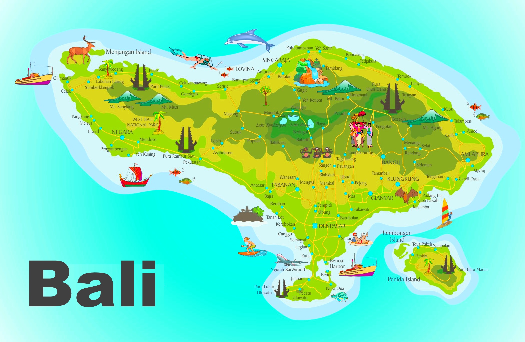
Understanding Bali’s Geography: A Regional Overview
Bali is divided into several distinct regions, each offering a unique atmosphere. To use a Bali map effectively, you must first understand the “vibe” of each cardinal direction.
South Bali: The Tourism Hub
This is the most developed part of the island. It is home to the Ngurah Rai International Airport (DPS) and the most famous beach clubs. If your map highlights areas like Kuta, Seminyak, and Legian, you are looking at the heart of Bali’s nightlife and shopping districts.
Central Bali: The Cultural Heart
Dominated by the town of Ubud, Central Bali is where you will find the iconic rice terraces, ancient temples, and art workshops. In 2026, this area remains the premier destination for wellness retreats and yoga enthusiasts.
North and West Bali: The Untamed Frontier
For those looking to escape the crowds, the northern coast (Lovina) and the west (Pemuteran) offer black sand beaches and world-class diving. These areas are featured prominently on modern Bali attraction maps for their eco-tourism appeal.
Major Cities and Hubs You Must Locate
When looking at a Bali Indonesia map with cities, focus on these primary hubs to orient yourself:
- Denpasar: The provincial capital. While often overlooked by tourists, it is essential for authentic markets and administrative needs.
- Ubud: Located in the uplands, it serves as the base for exploring the Tegallalang Rice Terrace and the Sacred Monkey Forest.
- Canggu: In 2026, Canggu has solidified its status as the world’s leading digital nomad destination, blending surf culture with high-end dining.
- Singaraja: The former colonial capital in the north, offering a glimpse into Bali’s history and a gateway to hidden waterfalls.
Mapping the Best Beaches in Bali for 2026
No Bali beach map is complete without categorizing the shores by their best use. Not all beaches are for swimming; some are for surfing, while others are strictly for sunset cocktails.
The Surfer’s Paradise: Uluwatu and the Bukit Peninsula
Located on the southern tip, the limestone cliffs of Uluwatu hide some of the world’s most famous surf breaks.
Padang Padang Beach: Famous for its appearance in “Eat Pray Love.”
Bingin Beach: A rugged, bohemian spot for expert surfers.
Suluban Beach: A unique cave-entrance beach that leads to incredible swells.
Family-Friendly and Calm Waters: Sanur and Nusa Dua
If you are traveling with children, look for the eastern and southeastern coasts on your map.
Sanur Beach: Known for its long boardwalk and sunrise views. The water is shallow and protected by a reef.
Nusa Dua: A gated resort area with manicured beaches and 5-star luxury.
The Trendsetters: Seminyak and Canggu
These beaches are wide, volcanic, and perfect for long walks.
Echo Beach (Canggu): Great for sunset vibes and seafood BBQ.
Double Six Beach (Seminyak): Famous for its colorful bean bags and live music.
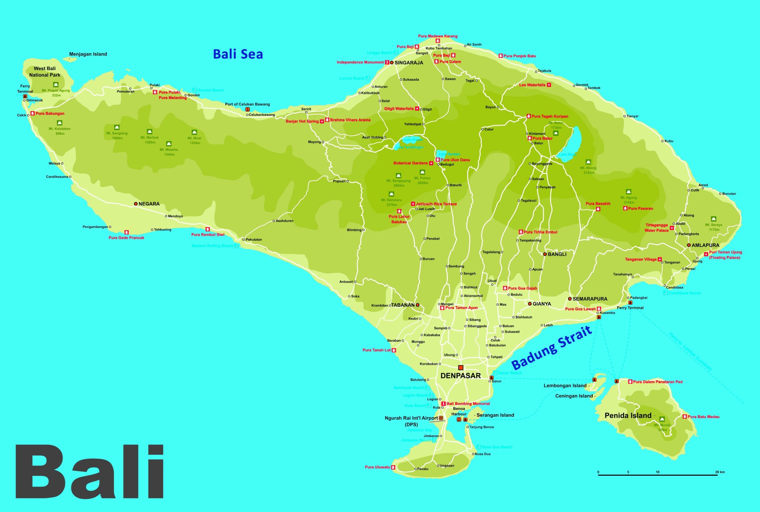
Interactive Maps and Digital Navigation in 2026
In 2026, the way we use a Bali travel map has shifted toward interactive, real-time technology. While paper maps are great souvenirs, digital versions now offer:
Live Traffic Updates: Essential for navigating the busy intersections of Kerobokan and Denpasar.
Waterfall and Temple Filters: Modern interactive maps allow you to filter by “hidden gems,” showing you less-crowded spots like Sekumpul Waterfall or Pura Lempuyang.
GPS-Linked Itineraries: You can now download pre-set routes for “3 Days in North Bali” or “The Ultimate Beach Crawl” directly to your smartphone.
How to Plan Your Route Using a Bali Map
To maximize your time, group your activities by proximity. A common mistake is trying to see Uluwatu and Ubud in the same day—the traffic makes this nearly impossible.
Day 1-3 (South Coast): Focus on the beaches. Map out a route from Jimbaran for seafood to Uluwatu for the Kecak Fire Dance.
Day 4-6 (Central Highlands): Move your base to Ubud. Use your map to find the Campuhan Ridge Walk and nearby waterfalls like Tegenungan.
Day 7-10 (The Islands): Don’t forget to look at the offshore islands on your map. Nusa Penida and Nusa Lembongan are just a 30-minute boat ride from Sanur.
Essential Travel Tips for Bali in 2026
Sustainable Travel: Many areas on the Bali map are now designated eco-zones. Be mindful of your plastic use and support local businesses.
Transportation: While scooters remain popular, the 2026 electric shuttle systems in Ubud and Canggu are a greener and safer way to get around.
Best Time to Visit: Use your map to plan for the dry season (April to October) if you want to explore the mountains, or the wet season for lush, green photography.
Conclusion
A Bali indonesia map with cities and beaches is more than just a guide; it is a blueprint for your adventure. By understanding the layout of the island—from the bustling streets of Seminyak to the tranquil shores of Amed—you can create a balanced itinerary that captures the true essence of Bali in 2026. Whether you are chasing the perfect wave, a spiritual awakening, or a luxury escape, having the right map ensures you never miss a beat in this tropical paradise.