Dreaming of emerald rice terraces, sacred temples, and world-class surf breaks? You aren’t alone. As we head deeper into 2026, the “Island of the Gods” remains the world’s most sought-after tropical sanctuary. However, before you book that flight, you need to know exactly where this paradise sits on the global stage. Understanding the Bali, Indonesia location on the world map is the first step in planning your ultimate getaway.
Pinpointing Bali: A Geographic Overview
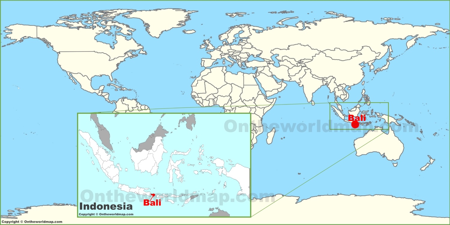
Bali is an island province of Indonesia, a vast archipelago nation that straddles the equator. When looking at a world map, you will find Bali situated in Southeast Asia. It lies specifically between the islands of Java to the west and Lombok to the east.
As an island, Bali is relatively small compared to its neighbors, yet it holds a massive cultural footprint. Geographically, it is positioned just south of the equator, which explains its tropical climate and consistent warmth throughout the year. It acts as a bridge between the Indian Ocean to the south and the Java Sea to the north.
How to Find Bali on a World Map
If you are struggling to spot it, follow these simple geographic cues:
Locate Southeast Asia: Focus your eyes on the region between the Indian Ocean and the Pacific Ocean.
Find Indonesia: Look for the massive collection of islands forming the Indonesian archipelago.
Identify the Lesser Sunda Islands: Bali is the westernmost island of this chain, sitting just off the eastern coast of Java.
Check the Latitude: You will find it located approximately 8 degrees south of the equator.
Being nestled between the Indian and Pacific Oceans provides Bali with its unique biodiversity. The island’s strategic position makes it a vital hub for international tourism and a gateway for exploring the rest of the Indonesian archipelago.
Why Geography Matters for Your 2026 Trip
Knowing the Bali, Indonesia location on the world map isn’t just for trivia—it dictates your travel strategy. Because of its location in the tropics, Bali experiences two distinct seasons: the dry season (April to October) and the wet season (November to March).
In 2026, travelers are increasingly using geographic data to plan “smart” itineraries. By understanding that Bali is east of Java, visitors realize they can easily bridge their trip with a visit to the famous Mount Bromo or Ijen Crater in East Java via a short ferry crossing.
Furthermore, the island’s position in the Coral Triangle—the global center of marine biodiversity—makes it a top-tier destination for divers. Whether you are heading to the north coast for muck diving or the south for world-famous surfing, your location on the map determines the best time of day and year to visit specific attractions.
Navigating the Island: Regions and Attractions
Once you arrive, the “map” of Bali becomes even more detailed. To make the most of your 2026 adventure, categorize your exploration by region:
- South Bali (Seminyak, Canggu, Uluwatu): The hub of nightlife, luxury villas, and surf culture.
- Central Bali (Ubud): The cultural heart, famous for its lush forests, yoga retreats, and terraced rice paddies.
- North/West Bali: The hidden gems. Home to the Bali Barat National Park and tranquil, black-sand beaches that see far fewer tourists than the southern coast.
- East Bali: Dominated by the majestic Mount Agung, this region is perfect for hikers and those seeking authentic Balinese temple experiences, such as Pura Besakih.
Using a dedicated Bali tourist map will help you visualize these regions. Most seasoned travelers recommend spending at least two weeks on the island to truly experience the diversity of these geographic zones without feeling rushed.
The Importance of Accessibility
Bali is highly accessible for international travelers, thanks to the Ngurah Rai International Airport (DPS), also known as I Gusti Ngurah Rai International Airport. Located in the south near Kuta, it serves as the primary entry point for millions of visitors annually.
Its location at the southern tip of the island makes it a convenient starting point for most travelers. Whether you are arriving from Australia, Europe, or North America, the island’s connectivity via major international hubs ensures that this tropical paradise remains within reach. As we progress through 2026, improved infrastructure and digital mapping tools have made navigating the island’s winding roads and hidden shortcuts easier than ever before.
Conclusion: Ready for Your Island Adventure?
Understanding where Bali is on the world map is more than just a geographic exercise; it is the foundation of a well-planned, unforgettable journey. From its strategic position in the Indonesian archipelago to its proximity to the equator, every aspect of Bali’s location contributes to the unique experience it offers.
As you finalize your plans for 2026, keep this map in mind. Whether you are chasing the surf in Uluwatu or seeking inner peace in the jungles of Ubud, Bali’s geography is your guide to the ultimate island escape. Now that you have the “where,” you are ready to focus on the “what” and the “how.” Pack your bags, keep your compass handy, and prepare to discover the magic of Bali for yourself.